Best Navigation App in 2026: 8 Apps Compared

- 1
 Google MapsBest all-round navigationVisit
- 2
 WazeReal-time traffic alertsVisit
- 3
 Apple MapsiPhone usersVisit
- 4
 HERE WeGoOffline maps and transitVisit
- 5
 SygicOffline GPS with extrasVisit
- Google Maps is the best all-round navigation app, with the widest maps, traffic and place data.
- Waze is best for real-time traffic, hazards and police alerts from its driver community.
- Apple Maps suits iPhone users with clean design and deep iOS integration.
- HERE WeGo, Sygic, TomTom GO and OsmAnd suit offline use, with OsmAnd best for fully offline maps.
Quick comparison
| Product | Ideal for | Price from | Free version | |
|---|---|---|---|---|
| Google Maps | Best all-round navigation | Free | Yes | Visit |
| Waze | Real-time traffic alerts | Free | Yes | Visit |
| Apple Maps | iPhone users | Free | Yes | Visit |
| HERE WeGo | Offline maps and transit | Free | Yes | Visit |
| Sygic | Offline GPS with extras | Free | Yes | Visit |
 TomTom GO | Trusted driving navigation | See website | Free trial | Visit |
 MapQuest | Simple US road trips | Free | Yes | Visit |
 OsmAnd | Fully offline open maps | Free | Yes | Visit |
The best navigation apps
A navigation app should get you there reliably, with accurate traffic, clear directions and useful place information. The eight apps below cover everyday driving, offline travel, trucking and community alerts, and they differ in map data, traffic quality and price. We compared official product pages, pricing pages and app listings.
Google Maps
Ideal for: Best all-round navigation

Google Maps is the default navigation app for most people because its maps, business data, reviews, photos and live traffic are the most complete available. It reroutes around congestion, covers driving, walking, cycling and transit, and works almost everywhere.
It uses more battery and data than offline apps, and its data collection concerns some privacy-focused users. For a single app that handles nearly every trip, Google Maps remains the best all-round choice.
- Widest map and place data
- Strong live traffic and rerouting
- Walking, transit, cycling and driving in one app
- Uses more battery and data than offline apps
- Privacy-conscious users may prefer alternatives
Waze
Ideal for: Real-time traffic alerts

Waze, owned by Google, crowdsources traffic from drivers: accidents, hazards, police, road closures and speed traps appear on the map in real time, with fast rerouting around problems. Its community is its strength, especially for commuters who want to know what lies ahead.
The interface is busier than Google Maps, and its place data is thinner. For a driver whose priority is avoiding traffic and hazards, Waze is the best companion app.
- Community reports on traffic, hazards and police
- Fast rerouting
- Fun, social driving experience
- Google-owned, so privacy concerns similar to Maps
- Interface can feel busy
Apple Maps
Ideal for: iPhone users
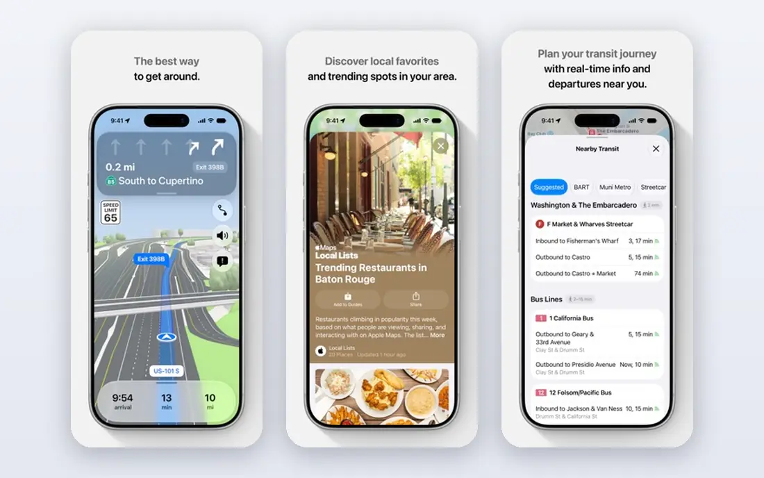
Apple Maps has improved greatly, with detailed city maps, 3D landmarks, natural language directions and deep integration with Siri, CarPlay and Apple Watch. Its privacy stance, with less personal data collection, appeals to Apple users.
It runs only on Apple devices, and place data can be thinner than Google outside major cities. For an iPhone user who values design and privacy, Apple Maps is an excellent default.
- Clean design with detailed city maps
- Deep iOS, Siri and CarPlay integration
- Good privacy stance
- Apple devices only
- Place data thinner than Google in some regions
HERE WeGo
Ideal for: Offline maps and transit
HERE WeGo offers free downloadable maps for whole regions, making it a strong offline choice for travelers without reliable data. It covers driving, transit, walking and cycling, with clear directions and a worldwide map base from HERE Technologies.
Live traffic is thinner than Google or Waze, and the interface is practical rather than beautiful. For offline travel and transit, HERE WeGo is a dependable free option.
- Free offline maps for whole regions
- Good transit and walking directions
- Works worldwide
- Traffic data thinner than Google or Waze
- Interface is functional
Sygic
Ideal for: Offline GPS with extras
Sygic is a GPS navigation app with offline maps, speed camera alerts, fuel prices, parking and a head-up display option that projects directions onto the windshield view. Its driver-focused extras suit long journeys and unfamiliar roads.
The free version covers basic navigation, with Premium adding full features and map updates. For a driver who wants offline GPS with extras, Sygic is a strong choice.
- Offline maps with speed cameras and fuel prices
- Head-up display option
- Good for drivers
- Full features need Premium
- Map updates vary by plan
TomTom GO
Ideal for: Trusted driving navigation
TomTom GO brings TomTom's long navigation heritage to phones, with trusted maps, live traffic, speed camera alerts and offline maps for trips without data. Its driving focus and clear instructions suit users who trust the TomTom brand from dedicated devices.
Full use needs a subscription after a trial, and place data trails Google. For a driver who wants a dedicated, trusted navigation app, TomTom GO is a solid pick.
- Trusted TomTom maps and traffic
- Offline maps
- Speed camera alerts
- Subscription for full use
- Less place data than Google
MapQuest
Ideal for: Simple US road trips
MapQuest remains a free, simple navigation option for US drivers, with a route planner that handles multiple stops well and clear driving directions. Its simplicity suits users who want basic navigation without extra features.
It is less rich than Google or Waze for traffic, places and international coverage. For a straightforward US road trip, MapQuest is a dependable free choice.
- Free and simple US navigation
- Route planner with multiple stops
- Good for basic trips
- Less feature-rich than Google or Waze
- International coverage thinner
OsmAnd
Ideal for: Fully offline open maps
OsmAnd is an open-source navigation app built on OpenStreetMap, offering fully offline maps, hiking, cycling and driving profiles, and no account or tracking. It suits travelers, hikers and privacy-conscious users who want maps without a data connection.
The interface is plainer and takes learning, and live traffic is minimal. For fully offline, private navigation, OsmAnd is unmatched on this list.
A further safety habit is setting your destination before driving, not while moving. Enter the address, check the route and traffic, and mount the phone where voice guidance is clear before pulling away. Adjusting navigation while driving distracts as much as texting, and no saved minute justifies that risk.
- Fully offline maps from OpenStreetMap
- No account or tracking
- Hiking, cycling and driving profiles
- Learning curve and plainer interface
- Traffic data is minimal
How we picked these
We compared official product pages, pricing pages and app listings, focusing on map accuracy, live traffic, offline support, voice guidance and place data. We favored apps that are actively maintained today and work reliably for everyday driving.
We also weighed the offline question: a navigation app that fails without signal is useless on rural roads and abroad, so offline capability scored highly for travel-focused apps.
How to pick a navigation app for your driving
Start with your typical trip. A city commuter needs live traffic and hazard alerts, so Waze or Google Maps fits. A rural driver needs offline maps, so HERE WeGo, Sygic or OsmAnd fits. An iPhone user who values privacy fits Apple Maps. Matching trip type to app matters more than any feature list.
Download maps before you leave
For any trip beyond your home area, download offline maps in advance, even if you mainly use Google Maps or Waze. Signal fails in rural areas, parking garages and abroad, and an offline map turns a dead zone into a minor inconvenience.
Pair a main app with a traffic app
Many drivers run Google Maps for directions and Waze for alerts, or Apple Maps with Waze in the background. That pairing gives the best of both: reliable routing plus community hazard warnings. Use a car mount and voice guidance to keep eyes on the road.
Check speed limits and cameras honestly
Speed camera alerts help avoid fines, but they do not replace watching signs and limits. Use alerts as a reminder, drive to conditions, and never let an app distract you from the road itself. Also keep a paper map or a downloaded offline map as backup on long rural trips, since even the best app cannot help without signal or battery. Also check whether your app supports lane guidance and roundabout directions for the roads you actually drive, since clear lane advice prevents last-minute swerves on busy motorways and complex city junctions. Test lane guidance on a familiar route first, so you trust it before relying on it somewhere new. Familiar routes make the best practice ground. Practice there before any long journey.
If you are still unsure, start with a free plan and move to a paid plan only when you hit its limits.
Frequently asked questions
What is the best navigation app?
Google Maps is the best all-round app, Waze is best for real-time traffic alerts, Apple Maps is best for iPhone users, and HERE WeGo, Sygic and OsmAnd are best for offline use.
What is the best free navigation app?
Google Maps, Waze, Apple Maps, HERE WeGo and OsmAnd are all free for core navigation. HERE WeGo and OsmAnd are best for free offline maps, while Waze is best for free traffic alerts.
Is Waze better than Google Maps?
Waze is better for community traffic, hazard and police alerts, while Google Maps is better for place data, transit and overall routing. Many drivers use both, with Maps for directions and Waze for alerts.
Which navigation app works offline?
HERE WeGo, Sygic, TomTom GO and OsmAnd all offer offline maps, and Google Maps allows offline map downloads for regions. Download maps before traveling to areas with poor signal.
Does Apple Maps work on Android?
No, Apple Maps runs only on Apple devices. Android users should use Google Maps, Waze, HERE WeGo, Sygic or OsmAnd instead.
Can navigation apps avoid toll roads?
Yes. Google Maps, Waze, Apple Maps and most apps here offer avoid tolls, avoid highways and avoid ferries options in route settings. Set preferences before departure, since changing them mid-route can cause confusing reroutes.